119 results
- Archives and manuscripts
- Online
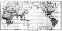
M0001540: Reproduction of a map of the world, showing the geographical distribution of malaria and blackwater fever
Date: January 1931Reference: WT/D/1/20/1/14/39Part of: Wellcome Trust Corporate Archive- Books
- Online
Some reflections on the uncertainty of many astronomical and geographical positions, with regard to the figure and magnitude of the earth, the finding the longitude at sea by watches, and other assertions of the most eminent astronomers. With some Hints towards their Reformation and Emendation. By Edmund Stone.
Stone, Edmund, -1768.Date: MDCCLXVI. [1766]- Books
- Online
A new practical geographical grammar. Containing, proper definitions of the abstruse terms that most frequently occur in reading the first principles of astronomy; with a short account of the hypothetical philosophy of the ancients; and a more particular description of the copernican or solar system. Wherein, the magnitudes, distances, and positions of the planets are briefly treated of; to which is prefixed, an explanation of the artificial sphere, and of the appendants and surface of the celestial and terrestrial globes. With directions for performing the most useful and curious astronomical, and geographical problems performed on each; and, a general description of all the remarkable countries in the world; with their subdivisions, chief cities, longitudes, latitudes, bearings and situations. Collected from the best authors, and rendered intellible to the weakest capacity. Particularly adapted to the use of schools. The firmament and stars declare the great creator's skill.
Caldwell, Eliza.Date: M.DCC.LXXIX. [1779]- Books
- Online
A practical method for finding the longitude and latitude of a ship at sea, by observations of the moon; with general rules for computing the same, illustrated by examples. Together with all the necessary Tables, and their Explanations. To which are added, Tables of the Time the Moon passes the Meridian of London, and her Declination, for the Years 1763 and 1764. With Examples of their Uses in finding the Latitude and Variation. By Robert Waddington, Teacher of the Mathematicks, in Three Tun Court, Miles's Lane, near the Monument, London.
Waddington, Robert.Date: MDCCLXIII. [1763]
- Books
- Online
Memoires pour l'histoire generale du diocese de Beziers. : Tirés des registres de l'Academie des sciences & belles lettres de la ville de Beziers.
Date: M.DCC.XXVIII..- Books
- Online
A treatise on the various lengths of the days, nights, and twilights, with tables of the latitude and longtitude of the most eminent towns, harbours, Headlands, and Islands, in the world, and their Bearings and Distance from London; with a short Discourse on Heat, Cold, and Twilight. The Whole being very plain and easy, diverting and instructive. Illustrated with a Copper-Plate, shewing The Length of the Days, Nights, and Twilights, at Bridge-Town, in Barbadoes, when the Sun is on the Tropicks and Equator. Also, A moveable Planisphere, neatly engraved on Copper, which, with a Semi-Circle of Sinical Hours, sheweth the Time of the Sun's Rising, Setting, and Length of the Days, Nights, and Twilights in all Parts of the Globe, when the Sun is in the Summer and Winter Solstices, and the Vernal and Autumnal Equinoxes; with its Description and Use. Likewise A moveable Orthographical Projection on the Plain of the Equator, with a moveable Index, neatly engraved on Copper, which will shew the Situation of any Place on the Globe; and also the Difference of Longitude and Time, between any two Places; and will solve several entertaining Questions the Globe; with its Description and Use at large. By Richard Mihill, Late Midshipman on Board his Majey's Ship Elizabeth.
Mihill, Richard.Date: [1755]- Books
- Online
On the doctrine of the sphere, in six books. Book I. Containing some preliminary Properties of the Cone. II. The General Doctrine of the Sphere. III. Of Spheric Angles and Triangles. IV. Of the Orthographic Projection. V. Of the Stereographic Projection. VI. Of Spheric Trigonometry. To which is added an appendix: containing the solution of a problem, for ascertaining the latitude and longitude of a place, Together with the Apparent Time. By the Rev. George Walker, F.R.S.
Walker, George, 1734?-1807.Date: MDCCLXXVII. [1775]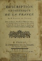
- Books
- Online
Description géométrique de la France / [César François Cassini de Thury].
Cassini, César-François, 1714-1784.Date: 1783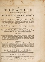
- Books
- Online
A treatise on the various lengths of the days, nights and twilights : with tables of latitude and longitude of the most eminent towns, harbours, headlands, and islands in the world ... / by Richard Mihill.
Mihill, Richard.Date: 1755
- Books
- Online
Voyage fait par ordre du roi en 1771 et 1772, en diverses parties de l'Europe, de l'Afrique et de l'Amérique; pour vérifier l'utilité de plusieurs méthodes et instrumens, servant à déterminer la latitude et la longitude tant du vaisseau que des côtes, isles & écueils qu'on reconnoît: suivi de recherches pour rectifier les cartes hydrographiques / Par M.rs de Verdun de al Crenne ... le chevalier de Borda ... et Pingré.
Verdun de la Crenne, Jean René-Antoine, marquis de, 1741-1805.Date: [1778]- Books
- Online
The longitude at sea, not to be found by firing guns, nor by the Most Curious Spring-Clocks or Watches. But the only true method for discovering that valuable secret by the sun, moon or stars, and an Exact Time-Keeper, with such Necessary Improvements, as have not yet been Describ'd by any other Person; and (with respect to the Term of any Ordinary Voyage) may properly be call'd a Perpetual Motion. Now Humbly Proposed, To the Consideration of the Publick, by Case Billingsley.
Billingsley, Case.Date: 1714- Archives and manuscripts
Material on specific geographic areas
Date: 1838-1864Reference: PP/HO/D/D166-225Part of: Hodgkin family- Archives and manuscripts
Notes and papers on civilisation, colonisation, the position of native populations and ethnology
Date: 1817-1864Reference: PP/HO/D/D99-237Part of: Hodgkin family- Books
- Online
New geographical tables. Exhibiting at one view all the empires, kingdoms, states, republics, provinces, title, position, situation, extent, climates, boundaries, sub-divisions, square miles, cities, chief towns, coronation places, villages, latitude, longitude, bearing, forts, ports, oceans, seas, gulphs, bays, streights, islands, isthmuses, capes, promontories, rivers, lakes, mineral waters, mountains, numb. of inhabit, languages, religions, fom of government, patriarchates, archbishopicks, bishoppricks, universities, academies, Ord. of Knighth, commodities, productions, curiosities, &c. In Europe, Asis, Africa, and America: including an authentic list of all the countires, cities, and boroughs, of great Britain and ireland which return members (and what number) to their respective houses of parliament. To which are prefixed, I. Directions for the use of the globes geographical definitions, climates, horary circle, and grand division of the world, on a new plan. II. Chronological tables of the sovereigns of England, Germany, France, Spain, Russia, Denmark, and Sweden, from the year 768 to 1775. With a list of unihabited islands, ruins of celebrated place, countries and places known by different names, and ancient names of remarkable seas and rivers, in the appendix. By John Povoleri.
Povoleri, Giovanni.Date: MDCCLXXV [1775]- Books
- Online
Geographical illustrations of Scottish history, containing the names of places mentioned in chronicles, histories, records, &c. with corrections of the corrupted names, and Explanations of the Difficult and Disputed Points, in the Historical Geography of Scotland; the Names being Alphabetically Arranged, with References to their Position in the Historical Map of Scotland, which Accompanies the Work: Together with a Compendious Chronology of the Battles to the Year 1603; Collected from the Best Authorities, Historical and Geographical, by David Macpherson.
Macpherson, David, 1746-1816.Date: 1796- Archives and manuscripts
Paper on position of native Americans in Canada, possibly for the Aborigines Protection Society, occasioned by visit of Catherine Sutton of the Ojibway tribe
Date: 19th CenturyReference: PP/HO/D/D173Part of: Hodgkin family
- Books
- Online
The geographical system of Herodotus, examined; and explained, by a comparison with those of other ancient authors, and with modern geography : In the course of the work are introduced, dissertations on the itinerary stade of the Greeks, the expedition of Darius Hystaspes to Scythia, the position and remains of ancient Babylon, the alluvions of the Nile, and canals of Suez; the oasis and temple of Jupiter Ammon, the ancient circumnavigation of Africa, and other subjects of history and geography. The whole explained by eleven maps, adapted to the different subjects; and accompanied with a complete index / by James Rennell.
Rennell, James, 1742-1830.Date: 1800- Archives and manuscripts
The Far East
Date: 1858-1859Reference: PP/HO/D/D213-218Part of: Hodgkin family- Archives and manuscripts
Central America: account of native Americans of Darien, by Emanuel Cardenas
Date: c.1852Reference: PP/HO/D/D177Part of: Hodgkin family- Archives and manuscripts
Upper Nile area
Date: 19th CenturyReference: PP/HO/D/D211-212Part of: Hodgkin family- Archives and manuscripts
Other areas
Date: c.1864Reference: PP/HO/D/D219-225Part of: Hodgkin family- Archives and manuscripts
South America: extracts from the writings of Baron Humboldt on the treatment of native Americans
Date: 19th CenturyReference: PP/HO/D/D178Part of: Hodgkin family- Archives and manuscripts
New Zealand
Date: 1839-1864Reference: PP/HO/D/D185-194Part of: Hodgkin family- Archives and manuscripts
The Middle East, and Jewish affairs in general
Date: 1857Reference: PP/HO/D/D196-204Part of: Hodgkin family- Archives and manuscripts
North America
Date: 1838-1848Reference: PP/HO/D/D166-176Part of: Hodgkin family